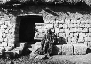
 History of Kurdistan
Related Articles

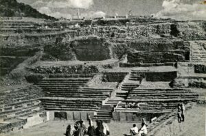
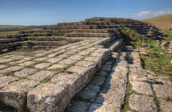
Considered one of the oldest dams in the world, Jirwana dam is located five kilometres to the east of Shekhan district and ten kilometres from ‘Khanis’ remains in Duhok province, Kurdistan Region. The architectural design of the dam is something that attracts instant attention due to its creativeness and arrangement. In the time of no technology, two million stones were extracted from the dam’s surrounding mountains and carved in such a geometrical way so that they would hold on in different rows.
The remains of the dam stretch up 280 meters long, 22 meters wide, and 9 meters high, and this is as far as the bare eye can see, but further archeological excavations might expose a much wider range of the dam.

Jirwana’s history is a long one as it dates back to 3,000 years ago, when the Assyrian King Sanharib (681-705 BC) built it. Jirwana dam can be considered as King Sanharib’s most important project since building it took a year and three months of non-stop work.
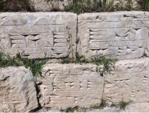
Muhammad Arf Tatar, a master’s degree holder in archeology and expert in reading ancient languages, translates some of the cuneiform texts inscribed on the stones into Kurdish and says: ‘according to the translation of the texts, King Sanharib says ‘I am Sanharib, the king of the world, the king of Assyria, the king of the entire world. I have brought water from Khanis to here, and I have built this dam so that my God Assur is content with me. I have delivered water to Ninawa to serve God Assur, my country and Assyria’s people; and to make them content with me, and I curse the previous kings before me for not executing this project.’
Jirwana dam was designed in a way that it could collect water until it overflew, or it could run through 13 floodgates.
Archeologists have formed two different assumptions as to where the name Jirwana had come from. The first assumption comes from some Arabic sources, and according to which Jirwana was the name of a stream full of water that was considered as the source of the land’s prosperity. The second assumption alleges that there is the Kurdish word ‘chirwan’ which means a pasture, and it was the name used to refer to the prosperous area of greenery and water for feeding animals, where the dam was built.
Archeologist Muhammad Tatar says ‘in the cuneiform texts and writings of the Assyrian times, it was mentioned that the word Jirwana refers to a place that has water, or it means having water.’
Building and naming the dam Jirwana proves the power that Kurdistan had as an important source of water for areas under the rule of the Assyrian empire and their capital city, Ninawa. It is not the only source of pride for the Assyrians and Kurdistanis, but also building many other important landmarks in that period of time and by the same king, like Khanis historical site and Bastura dam, are quite marvelous achievements.
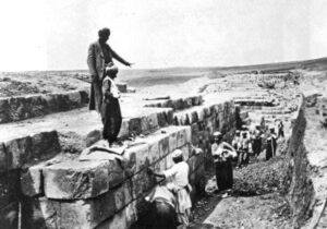
The history of Jirwana has not always been known, and it took many years and visits from many foreign archeologists to reveal its story. According to archeologist Covan Ihsan, Jirwana historical site was first discovered by the foreign archeologist Layard in 1845. Despite writing about it, Layard did not know the purpose behind the structure. Archeologist Tru Dan Jan and Lehmann Haupt also visited the site after Layard, but neither knew as to why such a structure was built.
Then came the year 1904, when the famous English archeologist W. King, then Spyzar, visited the site but they also did not reveal the story. The reason for the failure of experts was the thick forests covering the surface of the area, which prevented further investigations.
Professor Walter Bakhman, a member of a German archeological team that worked on the historical site of Assyria, visited the dam in 1913 and took many photos of the site. He believed that the site is of a barrage that water went over, then by organizing his information and other foreign archeologists’ discoveries and with the encouragement of archeologists like Yakubson and Stone Loid, Bakhman started to conduct thorough investigations at Jirwana.
The latest discoveries about Jirwana dates back to 1934, when the American Institute of Chicago investigated the historical site of Khursubat, and both archeologists Stone Loy and Yak Bison visit Jirwana. They revealed the architectural design and range of the dam as well as the reason behind building the structure. They discovered that Jirwana dam was a continuation of Khanis project to provide water to the area.
All the information related to the dam are discovered through investigating the stones at the site. Archeologists classified the stone inscriptions into four groups:
Text A, that is extremely difficult to read and understand, includes remarks about King Sanharib’s castle as the king of Assyria, the king of the world and his authority. Text B describes how the whole project of the dam was constructed. Text C and D are both about praising the Assyrian King Sanharib for building the dam and the Assyrian gods commending and helping Sanharib in the journey of building Jirwana dam.
The stones of Jirwana witness its great history and why it was such an important project at that time. They talk about the benefit of having Jirwana dam not only for the capital of Assyria, but also for many other areas and villages that used Jirwana’s water.
Jirwana dam is still considered as an architectural phenomenon in history, because its design was extraordinary and stunning for all the archeologists who worked on the site. The attention that it got from foreign archeologists has made Jirwana an important topic to be discussed at international universities.
However, it is unfortunate that many stones of the dam have been taken by locals and used in building houses or fences around fields, and now it remains as a pasturage for animals. The tempering of the locals and the lack of interest by the government and those responsible for the historical and tourist sites, has transferred the area from once a prosperous and green area to a deserted and a dry one.